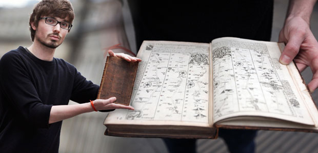
Photo via journallive.co.uk
It was a lovely surprise for the Oxfam bookshop.
They are peopled by volunteers. And a friend of one of these volunteers for the Newcastle store was a collector of books.
The donor was having a ‘clear out’, they said. And one of the things they cleared out was a book worth around £2300.
Personally, I cannot see how the donor could have let it go. For it is one of those books which, were I ever fortunate enough to have it slip into my possession, would never be allowed out again. I might even chain it.
For it is Britain’s first road atlas. Britannia Depicta.
Published in 1675. You know, for stagecoaches.
Its creator was a man who had many strings to his bow. A dancing master who founded a theatre before settling down, the year of Charles’s execution, to print publications. A man who gained the heavenly title of His Majesty’s Cosmographer – or mapper of the cosmos – at the age of 71. And at 75, a year before his death, he bequeathed us a priceless gift: the first readable, graphic map of the road.
His name was John Ogilby.
We don’t know anything about Ogilby’s parentage, though we do know he was a Scot from Forfarshire. We first come across him when he paid off his father’s debts at the age of 12, and later, when he was 19, was apprenticed to a London dancing master.
And so began a career in the theatre. He danced in The Gypsies Metamorphosed, a Ben Johnson masque. He was responsible for opening Ireland’s first theatre: New Theatre in Dublin’s Werburgh Street. This was hastily put a stop to in 1641, with the Irish Rising.
Returning to England he went first to Bristol, then Cambridge, and in 1648 he arrived back in London, marrying, and placing himself in a prime position to watch the shenanegans of the fall of Charles I.
And then he began to print: first books, and gradually, he made a foray into maps.
Which is where I met him. Because the maps he published a year before he died changed travelling on the road in Britain forever.
Ogilby published a set of road maps, mapping the 73 principal highways which were in use in the second half of the seventeenth century. But he didn’t just lay out a standard map. He took the same route the designer of the London Tube maps, Harry Beck, used all those years later. He forsook the idea of drawing maps geographically – and went topological.
Topology: where scale, distance and direction take second place to the points that link the journey. One look at Ogilby’s maps is a revelation, for each one is broadly a vertical line, travelling from the bottom of the page to the top. But all the way up that line are annotations and symbols which make it a vital way for stagecoaches and horseriders to navigate.

Image via fromoldbooks.org
Ogilby used a waywiser to measure out distances. There’s one preserved in the Oxford Museum of the History Of Science: a ‘great wheel’ which records the passing of the miles:

In time, they took Ogilby’s work and ‘improv’d’ it: and so the 1720 edition was born, improved by another gifted cartographer, Emanuel Bowen. It gloried under the name “Britannia Depicta” or “Ogilby Impov’d Being a Correct Coppy of Mr. Ogilby’s Actual Survey of all ye Direct & Principal Cross Roads in England and Wales: Wherein are exactly Delineated & Engraven, All ye Cities, Towns, Villages, Churches, Seats & scituate on or near the Roads with their respective Distances in Measured and Computed Miles.”
And a 1720 edition made it to Oxfam, where I expect it raised plenty of much-needed cash for charity.
I have never been so tempted to covet my neighbour’s goods.
Slideshow images from http://www.fromoldbooks.org and http://www.bouletfermat.com. Do take a look, also, at this broadsheet created by the Museum of the History of Science based around Ogilvy’s routes:

Reblogged this on Oyia Brown.
What a wonderful volume! Quite amazingly preserved. Like you, I am amazed that the donor considered it a suitable subject for being cleared out.
You’d have to prize that volume out of my cold dead hands, Col 😀
I may have been amazed at everything else, but that would NOT amaze me!
Oh I covet it too!
Wonderful, isn’t it?
I bet you want a copy and visit all those places to see how much they have changed or what jewels are hidden in the landscape.
Rafael, you know me too well. Can you imagine a book returning to these routes? Priceless…
Hard to believe at one time maps were artistry and surprisingly accurate.
To me even today’s maps have their arty side, Hudson. You may remember I came across a 1965 AA book of maps which has charmed me and informed me in equal measure. To own a facsimile of this set of maps would be something to pore over in my dotage 😀
Cool! Yesterday I donated 18 books to the library for its upcoming booksale. I’m fairly confident that none approached £2300 in value. 😀
Pass on a book and you pass a legacy to someone, Nancy. That’s why I love second hand bookshops so much: they are only passed on because they are worth it.
what a beautiful tale – the little details are gems. such diversity in your blogs from doggy do do one day to rare publications the next. thanks Kate
Thank you! Lovely to have you visit and read. I confess that at the beginning of most days I ave no idea what I am going to write. I am constantly surprised by what presents itself each day…
I wouldn’t mind owning the book myself (though I’m not sure if at the moment I could cough up £2300 for it). Love the long subtitle of the 1720 ed. – one doesn’t see that much any more…
I was intrigued to see “waywiser” (the word) – it brought me immediately in mind of a term I know from the German (LG & Du too) meaning ‘one who or that which shows the way’ – in that sense, Ogilby himself was a waywiser who used a waywiser (ped- or odometer sense) to measure distances for his maps.
And I should thank you for this quote I came across while researching the word:
“Why should one side of the mountains have all the crosses, and the other all the way-wisers?” —Walter White: To Switzerland and Back (1870).
Not sure why that pulls at me so, but now I’m looking for that book… 🙂
I can’t find anything on Walter White, how intriguing, Ruth! I wonder if Gutenberg has a copy online. A whole new trail to follow. Thank you for the new definition of waywisers, I had no idea – I had only come across them at the Ashmolean and then stumbled over them researching this volume.
What a wonderful find. Sometimes, things find exactly where they need to be at the right time. Ironic for this book, but good fortune, nonetheless.
Good fortune indeed. I’m sure the proceeds from the book went to help a whole village get water, or something of that ilk. Oxfam make their money go far 🙂
A lovely book. It’s an astonishing treasure. Seems like it should be in a museum.
It does. I’d love a copy blown up to A3 size for wach page. Or better still, wall canvases. I could stare at the maps for hours!
I remember we used to run a stall for my local Scout troop. Someone donated a set of Billy Bunter annuals to us which sold very well. But maps are something special as they give a sense of place, of juxtaposition.
Wow, I’d have loved to see those, Laurence. It’s a thrill when a valuable book appears out of context. But maps? As you say: they are very special.
Surely you jest? Just £2300 ? There must be some missing zeros there for such a book.
Is it not unique?
It is indeed. Though I am scoping out facsimiles which, it seems, can be had for £25 or so. But that original: it’s enough to make you sell the family car, isn’t it?
and the wife 😉
Beyond cool!
Amazing, we’ll soon be able to but the “Last Road Atlas” as sat navs continue their take over.
Satnav feels like delegating your brain to someone else, Snowgood. Though I recently ended up gallivanting in completely the wrong direction for about an hour’s drive and then dizzily blaming the satnav. I like maps, not so much because they tell you where to go, but because they show you what’s on the way. One of my treasures is a 1965 AA book of the road which does the modern equivalent of Ogilby. Fantastic to see what has changed, and what has remained. And it gives me so many leads!
If you’re travelling for pleasure a good map wins hands down. I like using a MIchelin Map to explore Europe, with my favourite drives being in Portugal and Spain keeping off the main routes, discovering everything from able cars to circling vultures – both by accident simply because I chosen the scenic routes. Mind you if you had a integrated Volvo Sat Nav like me you’d still get the scenic route, as the system is so poor!
I am crazy about maps. Always have been. There’s a special place in my heart for road atlases (had no idea they began so long ago). GPS is supplanting the big paper Rand McNally road atlases I used to buy and annotate liberally with notes about places to stay, quick lunch stops, speed traps, etc. Finally bit the bullet and threw the last one out just recently. It was probably 10-15 years old.
How I would have treasured an Ogilby atlas of the same routes!
I love the idea of anotating an atlas. If I ever picked up a map of the road with notes I think it would come very high up in my list of treasures, PT.
Maps and books, two of my weak points. I have a few old atlases. I used to buy a new one every year, but finally quit a couple years ago. I don’t drive in unfamiliar territory as much as I used to. But when I do, I still take along an atlas just in case :-). You never know when your data service will drop out on your phone. Especially in the mountains.
You sound like an incredibly organised driver, Steven. A new map every year! I like knowing what there is to see on the way. My iPhone has been a major book on long journeys: I can google all the way down the motorway, do a bit of virtual visiting.
Really Kate! I trust you stop the car while using your iPhone and Googling. Women drivers? Cheeeeeeeeeeeeee 😉
Thanks for this peek into such a treasure, Kate. LOVE the detail.
I just want one now, BB. I just want one.
Oh, Kate! That’s thrilling! Will you let us know how much revenue the book raises for Oxfam? Why does the original estimate seem so low (to me) for such a rare bit of historical ephemera? I love it when objects turn up in places where there needed!
Hi Courtenay: this all happened last NOvember. The sale of the book raised £2,000: you can read about it here:http://www.bbc.co.uk/news/uk-england-tyne-20387371
Kate, I had some liquid courage after The Grind this evening, and I might be more addle-brained than usual as I’m trying to catch up on blog reading … Do I understand this correctly, this extraordinary atlas was published in 1675 and someone donated it?!? I am all for de-cluttering, but that sounds like a rare book that should be kept in a temperature controlled glass case. I found an old pre-9/11 subway map in my closet a few years back — and I’m hanging onto that. Maps are very sexy.
You understand it corectly, Lame. I wonder if there is a time when one starts to let go of stuff instead of accumulate it? I can only imagine that the donator of this book no longer cared for earthly things. Me, I’d have paid the price to acquire that even if it meant selling the family car. The pre-9/11 map: I’d never considered how NY is still changing. I’m behind with my answers but the pub you led me to looked like a must-see the next time I visit. So much change in one small place.
New York continues to change pot-Hurricane Sandy. For almost the entirety of the first twenty years I’ve lived out here, the changes were pretty “meh”, but since the turning point that was 9/11, we’ve had monumental, historic change. I also think that as one ages, one is very familiar with the “before” so what comes “after” resonates so much more, if that doesn’t sound too inarticulate.
I’m coveting this gem from afar, Kate. What a generous donation – and, perhaps a timely one. To donate this book while he could see it appreciated and generate some money for a good cause rather than wonder if it would just be tossed or otherwise abused (horrors) is quite a noble gesture. Glad you and I weren’t vying for it at the same time! tee hee
We have much to thank the John Ogilbys of the world for. An invaluable contribution, indeed. Thank you, Kate.
Without maps, there’s no telling where we’d wind up – unless we’re geographically gifted. My husband is my map reader when I drive. I don’t envy those who have someone who stubbornly refuses to stop and ask for directions because they had no map to guide their way.
i would be guilty of that sin too. What a treasure! The ‘donor’ must have been out of his mind.
Fabulous post, Kate… and another character I have never ‘met’ within my quest for the, well, you know… I love maps myself… especially old ones! Can you imagine having a copy of that in a cupboard somewhere?
This is just fabulous! I am in agreement with you that if I were to have such a book, it wouldn’t leave my possession either. I love maps, and have been trying to find more maps of early California. By early, I don’t mean more than 50 years ago…I can’t afford anything older than that! 🙂 This is a treasure of a story!
How very interesting!
(BTW I was in that museum on Friday, looking at the Netsuke and the Astrolabes etc. Marvellous place. Did we pass each other on our tour? There was a wonderful curator there who held us rapt for about 10 minutes)
I think it’s doubly bad because you have now also influenced me to covet your neighbors goods.
WOW. Just…..WOW. I’m with you, if I had that book, people would have to pry it from my cold dead fingers. If I ever saw a similar atlas for the colonies or early US, I’d be sleeping with it under my pillow, most likely. What a huge, huge score that was for the Oxfam bookshop. I hope whoever purchased it takes really good care of it.